LRLMAN's Treasure Hunting!
Home of the Arc-Geo Logger Metal Detector Imaging System
EFNMR2015 Long Range Locator - First to use EFNMR Frequencies!

Introducing the new AGL-II logging system. The unit has many new features never seen in other loggers. This system is for the professional user well versed in computers and software. The AGL-II transmits data in its raw form and must be imported into software. If you want complete control over your data then you will have no problem.
Field Test at Old Spanish Treasure Cave.
Features:
1. The logger uses a SD Card for storage.
2. The logger has 2 modes of operation;
(1) GPS mode arc-geo logger where sample is 1 second intervals and samples are set. Auto and Manual log.
(2) SPS mode "Sample/Second" Where the sample rate can be set form 1 to 5.
In SPS mode you set and control how much resolution you need by samples/second.
4. Line Time does not have to be set by wasting time trying to tell how many seconds to set for a line scan. The AGL-II allows you to start walking and when you want to stop you can. The system will store that line time. Each line after will be the same. You only need to walk the same speed. Sample direction is zig-zag.
5. Now you can log VCO. This setting is used for most gradiometers with VCO output max at 3.5k. This mode can be used in both AGL and SPS modes. Some metal detectors have a VCO setting.
6. Now the logger has a ground balance. The unit will sample a reference signal and will display -/+ output from the reference sample. 2 difference outputs will be sent. Varying data and -/+ from ground reference.
7. The logger can log 0-5vdc. So the logger has 3 input type signals available.
0-5vdc, Audio and VCO.
8. Now there is a smoothing setting. If the data jumps around some, you can set a smoothing value. Sometimes interference from different sources can cause data to jump around. Smoothing is a digital filter to smooth the data. Default is 1.
$1950.00
Free Software to download for Arc-geo Logger. FoxTerm
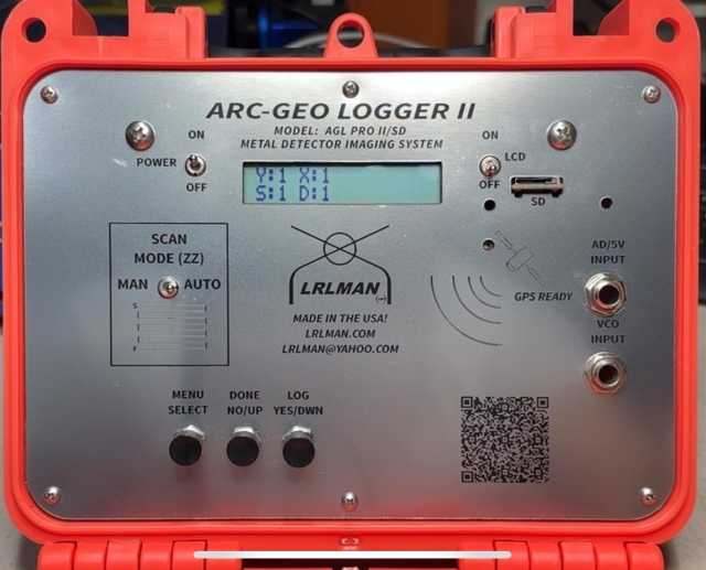
Logger shown has SD card and GPS added.
Options:
GPS
Wireless transmission
BLE "Blue Tooth"
SD Card
Any option can be added to the base logger.
The base logger comes with SD Card.